

Zdjęcia na płótno autora Juergen Wallstabe
FILTRUJ WYNIKI
Orientacja obrazów: wszystkie
pozioma
pionowa
kwadratowa
Rodzaj obrazów: wszystkie
zdjęcie
ilustracja
wektor
Zastosuj
#646834247
 XXL panorama evening aerial wide angle view of Hook Island, part of the Whitsunday Islands group...
#563793486
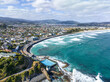 Beautiful high angle aerial drone view of a hot salt water pool in St Clair, a beachside suburb of...
#445688490
 Stunning wide angle panoramic aerial drone view of the City of Sydney, Australia skyline with...
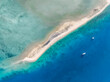
#646833995
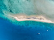
 Aerial bird's eye view of the reef crest, edge or border between the open blue ocean and the...
#552732768
 Early morning sunrise high angle aerial drone view of the Cathedral of the Sacred Heart of Jesus, a...
#563793524
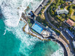 Beautiful high angle bird's eye aerial drone view of a hot salt water pool and the ocean in St...
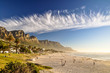
#563794051
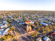
 High angle aerial drone view of St Clair, a beachside suburb of Dunedin, second-largest city in the...
#552732641
 Early morning sunrise high angle aerial drone view of Sturt Park, a recreational park named after...
#533656864
 High angle aerial drone view of Langford Island's sandspit or sandbar, a small islet near Hayman...
#408065550
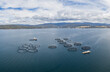 Panoramic aerial drone view of a large salmon fish farm (Aquaculture of salmonids) off the coast of...
#563793641
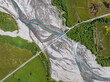 Bird's eye aerial drone view of Glenorchy-Paradise Road crossing over Rees River near Glenorchy,...
#574665789
 Beautiful evening aerial drone view of Lion Island, Pearl Beach, Umina, Box head and the Central...
#563794034
 High angle aerial drone view of Tomahawk Beach, Lawyers Head (and beach), Saint Kilda Beach and...
#563793500
 High angle aerial drone view of St Clair, a beachside suburb of Dunedin, second-largest city in the...
#552732574
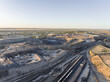 Early morning high angle aerial drone view of a big open pit silver, zinc and lead mine located...
#533656938
 High angle aerial drone view of Langford Island's sandspit or sandbar, a small islet near Hayman...
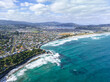
#122563212
 Stunning evening photo of Camps Bay, an affluent suburb of Cape Town, Western Cape, South Africa....
#646833858
 Aerial bird's eye view of the reef crest, edge or border between the open blue ocean and the...
#444761791
 Stunning wide angle panoramic aerial drone view of the City of Sydney, Australia skyline with...
#533656622
 XXL high resolution panoramic high angle aerial drone view of Langford Island near Hayman Island, a...
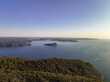
#92555897
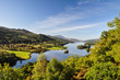 Beautiful summer view across Loch (Lake) Tummel seen from Queen's View, a famous viewpoint. Located...
#533656775
 Beautiful high angle aerial drone view of famous Whitehaven Beach, part of the Whitsunday Islands...
#445882260
 Stunning wide angle panoramic aerial drone view of the City of Sydney, Australia skyline with...
#563793706
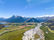 Beautiful high angle aerial view of Rees River, Mount Earnslaw and the Glenorchy-Paradise Road near...
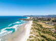
#408179398
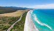 Stunning high angle aerial panoramic drone view of Denison Beach and the A3 Tasman Highway just...
#552732755
 Early morning sunrise high angle aerial drone view of the Cathedral of the Sacred Heart of Jesus, a...
#552732739
 Early morning sunrise high angle aerial drone view of the Cathedral of the Sacred Heart of Jesus, a...
#646834595
 High angle aerial bird's eye drone view of the rocky coastline and tiny beaches on Arkhurst Island,...
#646834360
 Aerial bird's eye view of the reef crest, edge or border between the open blue ocean and the...
#646833493
 High angle aerial bird's eye drone view of a small beach section of Haman Island, a holiday resort...
#127001668
 XXL panorama of Table Mountain and the Twelve Apostles mountain range seen from Lion's Head near...
#533656636
 XXL high resolution panoramic high angle aerial drone view of Langford Island near Hayman Island, a...
dodaj do ulubionych